Kailua-Kona (Hawaii)
Here is general information about Kailua-Kona in Hawaii
Kailua-Kona statistic
| Coordinates | 19°39′0″N 155°59′39″W |
| Elevation | 7 ft (2 m) |
| Time zone | UTC−10 (Hawaii–Aleutian) |
| ZIP code | 96740 |
| Area code(s) | 808 |
| FIPS code | 15-23000 |
| GNIS feature ID | 365355 |
| Area (Total) | 19.19 sq mi (49.71 km2) |
| Area (Land) | 13.80 sq mi (35.73 km2) |
| Area (Water) | 5.40 sq mi (13.98 km2) |
| Population (2020) (Total) | 19,713 |
| Population (2020) (Density) | 1,428.79/sq mi (551.66/km2) |
Other cities info:
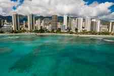
Kailua-Kona is an unincorporated community and census-designated place (CDP) in Hawaii County, Hawaii, United States. It is also known as Kailua (a name it shares with a community located on the windward side of Oʻahu), as Kona (a name it shares with the district to which it belongs) and as Kona Town. Kailua-Kona is the second-largest settlement on the island of Hawaii (after Hilo) and the largest settlement on the west side of the island, where it is the center of commerce and the tourist industry. Kailua-Kona is served by Kona International Airport, located just to the north in the adjacent CDP of Kalaoa. The population was 19,713 at the 2020 census, up from 11,975 at the 2010 census. Kailua-Kona was the closest major settlement to the epicenter of the 2006 Kiholo Bay earthquake.
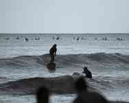
Kailua-Kona photos